Shop

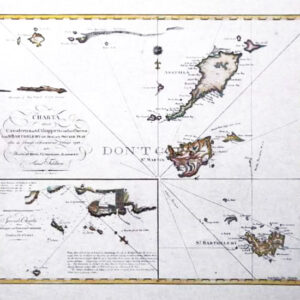
#07 Caribs Islands 1784
$55
Chart of the Antilles, or Charibee or Carib Islands, with the Virgin Islands
Cartographer: L.S. De La Rochette
Published in 1784 by William Faden for King George III. The work features a compass rose with rhumb lines for sailing direction. The top right inset provides a smaller version of the map indicating distance between islands, sailing routes, and longitude and latitude of each island. The right side includes an inset of the headlands of each island as they would appear to sailors.
Image size: 18 1/4″ x 20 1/2″
Paper size: 20 1/4″ x 23 1/4″
$10.00 shipping
Shipping is for the United States only.
For international, please email or call us to arrange method.